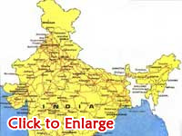
Indian railway Map would help in exploring
various destinations that are served by the Railways. Check out Rail
Route Map of India.
Indian Railway Map
Indian Railway has a vast network of
rail tracks throughout the dimensions of India. The network covers 28
states, 3 union territories and some areas of Nepal, Bangladesh and
Pakistan. Indian Railways (IR) uses a rail track of 108,805 kms approx
in total length; whereas the total route length of the network is not
less than 63,465 km. Himsagar Express covers the longest distance of
3751 km on the rail tracks from Jammu Tawi to Kanyakumari.
Indian Railways has divided the country into four main and twelve other
zones on the basis of their coverage area, divisions etc. IR is
acclaimed to encompass one of the largest rail networks in the world.
Indian Railway Map helps in knowing about the wide coverage provided by
the trains of India. This railway route map of India would also assist
in exploring the all destinations that are served by the Railways. Check
out the Rail Map of India.


